 |
| EHVB in de verte |
The military basis has closed down for quite a while already, but the land is still government property. ACV is merely tolerated there for history's sake, together with the Glider club and Model Airplane Club. But people from outside cannot simply land there. Only certain visitors of national level (heads of state, prime ministers, ...) get that privelage. Not too long ago, one would even need a complete military screening procedure to eb allowed on the premesis (either through the gate, or from the air). Now, that would even not be a problem (previous work had me screened for military class "secret"), but it takes typically two to six weeks toe process a request. So, simply deciding one morning to fly to Valkenburg, has never been an option.
Another thing is that the airfield is pretty much on the extended center line of Schiphol's runway Kaagbaan (06/24), at about 10nm out. That's just about where "the commercial plots call "established on the localizer". So the airspace near Valkenburg is class A (forbidden for visual flights, as we hobbyists do) from 1200ft upward already. With minimum altitude of 1000ft because of all the built-up areas, that leaves not much margin for error or traffic avoidance.
I went to meet Frank at 12:300 at Hilversum Airport. hen I arrived, the other WT9 of the flight school was already parked, ready to also fly to Valkenburg.
 |
| PH-4G3, the other WT9 of Dwarf Powered Gliders |
But before we can go, we first visit the tower to tell the aiport manager / Air Traffic Controller of our intentions (round trip Valkenburg, returning this afternoon). So now the ATC knows what to expect already, and in case we do not return, and do not report that that was intentional, he will call Search And Rescue.
After visiting the tower, the next thing to do is fuel up. One needs to be able to not only make the intended flight (round trip, as there are no fueling facilities at Valkenburg anymore), but also make it an alternate, with fuel to spare. An alternate in this case could be Lelystad, but chances are that if you can't make it to Hilversum because of weather, that same weather will ruin your chances at Lelystad. Rotterdam seems a more logical choice then (Schiphol is waaaayyy too expensive). Returning to Valkenburg would not be the best idea, because the plans were to start (re-)construction work on Monday, so the airport would then be officially closed.
So: we took on enough fuel to cross half the country. That meant MTOW (Max Take Off Weight); borderline legal.
 |
| Fuel up... |
After a struggle with suction cups, wifi settings, extra wires and more of those frizzles one seems to need with these modern gadgets, I am finally ready: action cam stand-by, remote switched on, DSLR within reach, ... let's go!
I had never flown fron Hilversum Airport, so I got a little confused which markers belonged to which runway, and how one is supposed to taxi. On asphalt, it's clear. Just follow the yellow line, and when you hit the grass, you know you've done something wrong. This was something different: a big square patch of grass with all those red-white markers indicating three crossing runways, plus two glider launch sites, and some parking indicators... From the air, it's all quite clear, but from low to the grond, it's more like a busy meadow.
I had never flown fron Hilversum Airport, so I got a little confused which markers belonged to which runway, and how one is supposed to taxi. On asphalt, it's clear. Just follow the yellow line, and when you hit the grass, you know you've done something wrong. This was something different: a big square patch of grass with all those red-white markers indicating three crossing runways, plus two glider launch sites, and some parking indicators... From the air, it's all quite clear, but from low to the grond, it's more like a busy meadow.
Ah well, it;s Frank's home base, so he knows his way around blindly. There's a fair bit of wind (10 to 15 knots) from the east, so 07 is the runway in use. As soon as we climb out above the trees that surrond the airfield at two sides, we get set away to the left quite abruptly. Somewhat scary, but good fun at the same time. A good opportunity for Framk to demonstrate his ability :)
The WT-9 is lighter than the Aquila, and therefore more susceptible to crosswinds. It is also very sensitive to stick movements,much like the Aquila, I think (I need a bit more experience to really judge that).
The journey to Valkenburg to about half an hour. Just south of Nieuwkoop, then North of Alphen a/d Rijn, over Woubrugge, and then via the north edge of Oegstgeest around Katwijk to join the Valkenburg circuit. Very nice to fly below Schiphol CTR3, which is the approach sector for the landing commercial traffic to Schiphol, this day.
The approach to Valkenburg starts at the KAtwijk lighthouse, but that was difficult to discover. Or better: the white building was very well discernible, but it wasn't very obvious it was a lighthouse. It's a converted church, and that's what it looks like. I did not even see the white building, from the right-hand seat, so I could not be of much assistance here.
From there, we turned inland to join mid-downwind runway 05. It was kinda busy in the air, and on the radio, so eyes wide open! It even took until final before Valkenburg Radio acknowledged contact. On short final, we got "set aside" again by a gust of ccrosswind. But Frank got it all under control, and well, with 2.5 km (1.5 nm) worth of runway, he had all the time in the world to get lined up again. It was even quite a long runout anyway, before we got to the first taxiway to vacate the runway. So a long flare was not a problem at all!
The picture above shows the parking line for visiting planes on the left. Busy, for a closed airport! :) Just near the furthest parked airplane (so where we parked), but on the right side of the runway, was the harbourmaster's office. We would need to get there to pay the landing fees (and get our coffee). That's quite a walk, since it's not allowed to cross an active runway... There was a shuttle service from the threshold, with private cars, and walking down the parking line with all those planes is never a problem, of course!
After our trip to the harbour master we sat down with a cup of coffee to watch planes that were leaving already. KLM Aeroclub was also present at EHVB, with the Cessna 172 PH-JBH. That plane just got re-painted, so I had to go over and take some pictures.
The journey to Valkenburg to about half an hour. Just south of Nieuwkoop, then North of Alphen a/d Rijn, over Woubrugge, and then via the north edge of Oegstgeest around Katwijk to join the Valkenburg circuit. Very nice to fly below Schiphol CTR3, which is the approach sector for the landing commercial traffic to Schiphol, this day.
 |
| Never flew this close to a 737 before |
From there, we turned inland to join mid-downwind runway 05. It was kinda busy in the air, and on the radio, so eyes wide open! It even took until final before Valkenburg Radio acknowledged contact. On short final, we got "set aside" again by a gust of ccrosswind. But Frank got it all under control, and well, with 2.5 km (1.5 nm) worth of runway, he had all the time in the world to get lined up again. It was even quite a long runout anyway, before we got to the first taxiway to vacate the runway. So a long flare was not a problem at all!
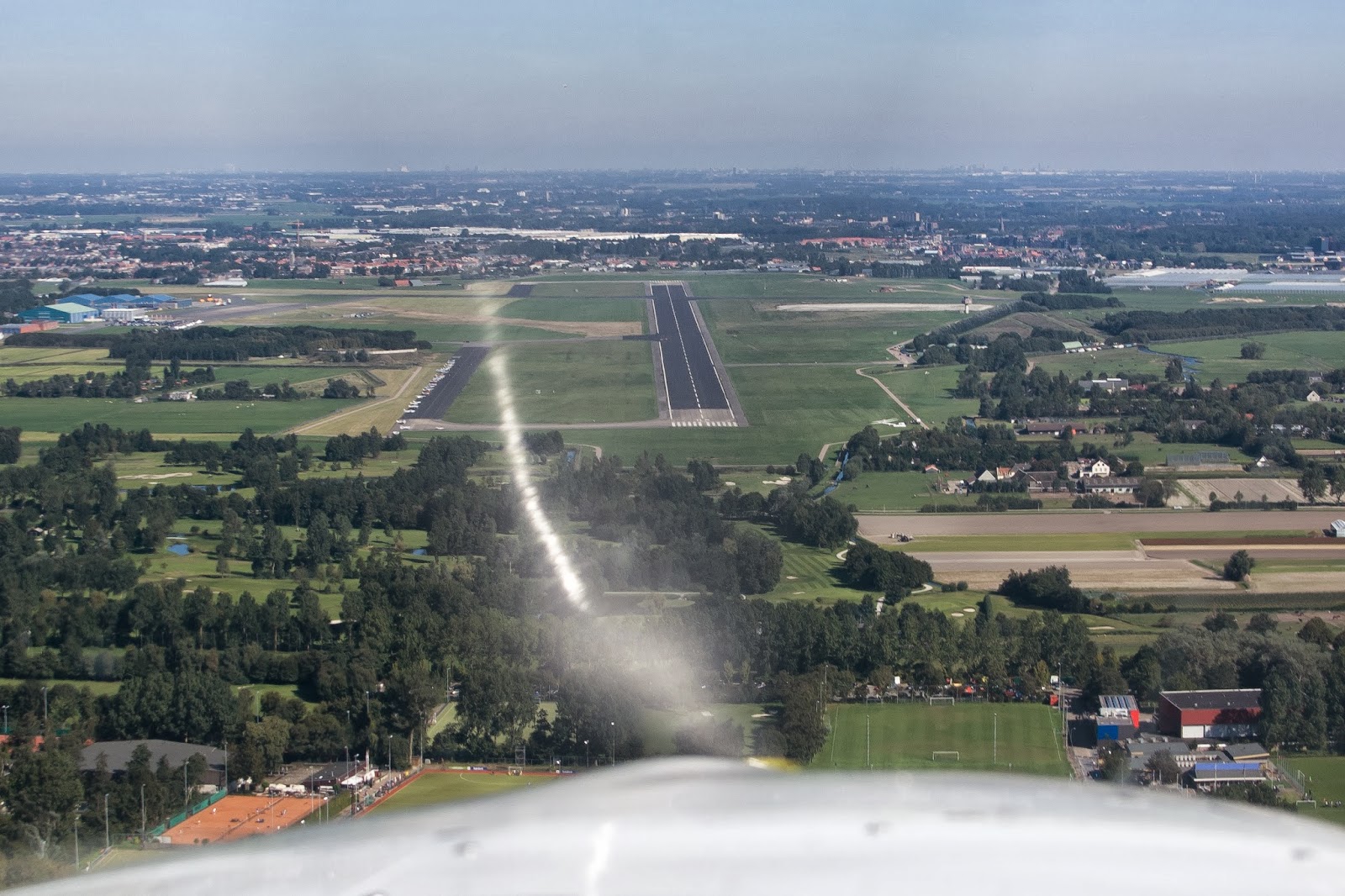 |
| On final EHVB |
After our trip to the harbour master we sat down with a cup of coffee to watch planes that were leaving already. KLM Aeroclub was also present at EHVB, with the Cessna 172 PH-JBH. That plane just got re-painted, so I had to go over and take some pictures.
 |
| PH-JBH, taxiing out |
As we got back to the plane, I saw that I did stop the camera, but did not shut it off, so now the battery was empty. Too bad, no movie of the return trip. I did manage to get an GPS track of the return trip, though, which did not work for the first leg. Conclusion: I need a bit more practice with those gadgets!
Ah, well, most important is of course that I can say that I was there, at the last fly-in of Valkenburg Aerodrome. A unique experience!
After a cola at the Airport Restaurant Hilversum, we both went our ways home for dinner. A perferct end to a perfect day :)
For those that are interested: I have the movie of the entire trip EHHV-EHVB below. It is uncut, so the full 34 minutes length. You can skip pieces as you please, of course. I just did not take the time yet to edit the footage.
EHHV-EHVB footage
And here's the Google Earth File of the return flight (or actually, the "recording" already started at the harbour master). Altitude information near Hilversum was not very reliable, apparently, but the route seems pretty accurate.
No comments:
Post a Comment